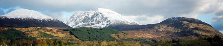
National Three Peaks Challenge
Team Information Pack
-
this regularly updated map and information bundle is ideal for small to medium
sized teams who are undertaking the challenge independently, and
want the best possible preparation . Each Pack contains:-
Two complete sets of our
unique challenge mountain maps
in PVC wallets - each set comprises three weatherproof maps, one for
each mountain route. The preferred routes are highlighted
on the map, and the reverse side has detailed route finding and
safety information with GPS data. The main map scale is 1:25,000
(lower section of Snowdon's Llanberis route is at 1:50.000).
The latest Three Peaks
Challenge Team Guide - nine pages of what some people
have called "insider" information
about the challenge designed to be used in conjunction with the mountain guide-maps
and this website.
The original version of the
Team Guide was
described as "a most valuable document" and now
we think its even better.
One set of flat laminated
mountain guide-maps -
these are ideal for team route planning before the event and for use by support
crew/drivers on the day of the challenge (keep them in the car).
Plus our regularly updated
"Top Tips" guide to a successful challenge (updated
most months).
The information pack has been revised
again recently with
more helpful tips and advice, and we
think it is now even more useful when preparing for the challenge.
The challenge
Team Guide and the extra information sheets are not available
separately, but they may be purchased for £3.75 if bought with one or
more
mountain guide-map sets.
The
Team Pack includes suggested driving
routes, but it does not contain any road maps.
The standard challenge
mountain guide-map set covers our recommended route to Scafell Pike
starting from
Wasdale Head. The alternative Scafell Pike route options
starting
from Seathwaite in Borrowdale are covered by a separate
guide-map (17TP), which may be specified when ordering, or both
options can be included for an extra £2.50.
If you are buying the Team
Pack and are undecided on the starting
point for Scafell Pike, or just want both options available,
then maps for both Scafell Pike route options can be included in
the bundle for a nominal additional cost of £4.00.
See
the
price list for all available options. Details
of all the routes covered are given in the table at the bottom of
this page >>>
The
Team Information Pack is £37 with free
UK post and packing.
Currently the special Team Packs are
available only directly from Beacon Maps. If you would prefer a different
package for your team (if you have more than about six walkers you
may want additional maps for example), then please don't hesitate to ring or email us,
and we will be pleased to offer advice if required and quote the best price
we can for the map/information package you require.
Support Mountain Rescue and find yourself with a Where-wolf card!
Buy one of these simple credit card sized
grid reference finders (Romers) to support Mountain Rescue and take the guess-work
out of finding accurate grid references. Just place the square
grid over the map and
read off the grid reference - they are ideal for GPS users and
carry the official Mountain Rescue logo.
Available with 3 Peaks map sets (TPC sets or Team Packs) for
£1.50 each, plus a donation of at least £1 to Mountain Rescue
England and Wales (minimum price £2.50 each). Sorry, these are no
longer available, but we know of a good alternative, please see the
price list
for details.
Harvey Maps Pocket
Magnifier - a neat
credit card sized magnifier that makes it easier to see fine detail
on maps etc - £1.50 each.
SILVA
Mk 4 Expedition
Compasses
If you need a good compass for your next trip or mountain challenge we
usually have
a small quantity of
these excellent compasses
available (this is the type we use on the
hill ourselves) - please phone or email
for availability and price.
Get mountain safety tips from the experts in Mountain
Rescue We have the latest version
of the pocket sized Mountain Rescue Handbook in stock - this is a handy, compact guide to safety on the hill, with
very useful information and advice from Mountain Rescue team members.
As a special offer to help promote mountain safety awareness we are making these available
to our
customers for £9.99 each plus just £1 post and packing. Order your
copy now -
more info.
To see
all the map and related products we have available please see our
Price List.
PREPARING FOR THE CHALLENGE
Careful planning, preparation and training is
the key to success when attempting the National Three Peaks. Read as much as possible about the Challenge and study the guide-maps
(and the Team Pack information if you have this) before the event. Also have a look at our
main links page
for other useful sources of information.
We would recommend that a small
team (say up to about six walkers) has at least two maps with them
on the mountains for safety. Larger groups will require
more maps, both for safety and flexibility. Our special Team
Packs are ideal for small or medium sized teams preparing for the
challenge. If you have any questions about
the choice of mountain route, preparation, pre-event training, timings
or use of GPS etc, please don't hesitate to
give us a ring,
we
will help if we can.
For typical times for a 24 hour challenge
attempt and the record for the fastest time see the
timings
page.
For three peaks challenge mountain
navigation issues see
Three Peaks challenge navigation problems.
If you are going to attempt the
challenge in anything like 24 hours or 36 hours, then for your own safety, and
the safety of other road users, you will need at least one, and ideally two,
competent drivers/co-drivers who will not be undertaking any of the
climbs. Don't be
tempted to allow the climbers to share the driving because they will
be too fatigued to be safe on the road.
If you are looking for a
professional guide to help with your challenge (for Scafell Pike for
example) we have a short list of guides who may be able to help -
please contact us for details.
REGISTERING FOR THE CHALLENGE
There is no official body
overseeing the three peaks challenge and no official website that
you need to register with, the challenge has just grown organically
in the hill walking community and now attracts people from all walks
of life. However large groups should register
their event with the people responsible for managing the mountain
environment and the visitor facilities / car parking etc to
prevent chaotic overcrowding caused by too many large events taking
place at the
same time.
If you are part of a small
independent group of no more than about 10 then you don't need
to register with anyone, but if you can it is wise to avoid the
weekends around the end of June, early July, because this is a very
busy time for the challenge.
The majority of people who
complete the challenge each year do so in small independent
self-guided teams. However many larger organised groups also
undertake the challenge on a regular basis and they should register their events.
If you have a large group and your event is using the Glen Nevis
Visitor Centre car park near Fort William (for Ben Nevis) then you
should liaise and book with the manager of the Glen Nevis Vistor
Centre. There is
a Ben Nevis events calendar at
www.bennevis.org/events-calendar.
Large groups are asked to pay a charge to help
maintain the facilities at the Vistor Centre.
If you are organising a large group event it is a very good idea to liaise with
the Visitor Centre well in advance.
Groups of more than about 10
- 20 walkers should also register their event with the Three Peaks
Partnership at
www.threepeakspartnership.co.uk.
Large organised charity groups
should also be following the special three peaks challenge code of conduct
drawn up by the Institute of Fundraising (IoF), although this now
appears to be a little out of date. Further info
is given below.
SOURCES OF INFORMATION
Each year considerable sums of
money are raised for charities by people taking part in sponsored
three peaks challenge charity events. Our links page and
a search of
the internet will reveal some of the many organisations involved.
The
Links page contain lots of useful info.
regarding the three peaks challenge and other resources for UK
mountain goers. If you would like to see other information
added to this page then please let us know.
Three booklets are available
(possibly more):- "The Challenge Manual" by Guy Newham, published in
1997 - "The National Three
Peaks Walk," by Brian Smailes, published by Challenge Publications
(revised in 2000) - and "Three Peaks, Ten Tors," by Ronald Turnbull, published by Cicerone
in 2007.
Bear in mind that some published information about the challenge can
become out of date quite quickly.
There is also the regularly
updated Beacon Maps Challenge Team Guide & Handbook. This brings together a lot of
real world practical information which will help you to
understand, plan and complete the challenge successfully. The
Team Guide is part of our Team Pack, but it may be ordered
separately.
WHEN & HOW TO DO IT
There are a several ways of
getting involved with a Three Peaks Challenge. The three main ones
are:-
1) Joining a organised
sponsored charity event (usually requires sponsorship and
an entrance fee)
2) Joining a professionally
run and supported challenge or Open Event
3) Organising your own
independent team event with a group of friends or colleagues
etc. This is how most people now undertake the challenge.
Our links pages gives details of
some of the organisations and charities that run challenge events on
a regular basis. They tend to get booked up fairly quickly so
need to be booked well in advance. The charities normally
require a specified minimum sponsorship amount plus an entrance fee.
The Beacon Maps challenge web
pages and our
Team Packs aim to help independent groups who are organising
their own Three Peaks Challenge, with or without assistance from
professional guides, but nearly all the information and the special
TPC guide-maps are equally of value to those taking part in an
organised event - many of which we help to support.
Thousands take on the National Three
Peaks Challenge each summer and many big groups take part at the peak
times between mid June and early July, hence it is better to avoid these times if
possible, especially at the weekends. The weather conditions are
often more favourable in spring and again in late summer.
There is lots of information and an on-line diary of
events for Ben Nevis (the Glen Nevis Visitor Centre)
which includes Three Peak Challenge events at
www.bennevis.org Large groups should book with the
Glen Nevis Visitor Centre well in advance to avoid overcrowding and
overwhelming the limited facilities.
A winter three peaks challenge is
possible for properly equipped adventurous teams with adequate
winter mountain experience and it is sometimes attempted in winter
conditions over a three day period (or more), see Maximum Adventure
on our Links Page for example
visit
site.
For a 24 hour challenge mid May to late September will
normally give the best chance of success
depending on
weather conditions. Remember that spring comes
later in the Highlands than down south, and in May there may still
be a fair amount of snow on the Ben. Old snow on the summit area is
not normally a problem for confident walkers, but the Mountain Track
can become very icy in early spring 'freeze - thaw' conditions
requiring the use of ice axe and crampons.
It's worth bearing in mind that the Three Peaks do not have to be
done in under 24 hours to make a worthwhile and demanding challenge. They
can be done in 36 hours, over two or three days, or over a longer
period. It can be a personal challenge, and if you wish you can set
your own goals which avoid the more anti-social aspects of a 24 hour
challenge.
For a very unusual Three Peaks
charity challenge have a look at the unique Railway Children event which uses rail travel between the
mountains and is completed in under 36 hours - last years
successful event raised over £200,000, see
www.railwaychildren.org.uk
If you are interested in taking part in the Railway Children
challenge event yourself in 2018 have a look at our special
railway children page.
Local Communities: If you are organising or taking
part in an event please give consideration to the impact on
communities around the three mountains. This applies
especially in the Lake District, where teams often arrive / depart
at night and the facilities do not exist to cope with large numbers.
Please plan your itinerary to minimise disturbance at unsocial hours.
IoF Code of Conduct: In 2010 a
new code of conduct,
intended to reduce the problems caused by very large
groups all doing the National Three Peaks Challenge at around the same time,
was
agreed by interested parties, including the land owners and
the major fundraising charities represented by the Institute of
Fundraising (IoF).
The code has been revised again
since then, but it is not completely up to date. Basically it asks
large charity event organisers to register their events well in
advance with the Glen Nevis Visitor Centre to avoid excessive overcrowding. Also it asks IoF
members
to avoid the most busy times for the challenge, i.e. Bank Holidays
and the weekends around the longest day and, very importantly, to avoid disturbance to
local communities at night (11PM to 5AM).
Another key point in the IoF code is
that it asks event organisers to agree a fixed time for the driving
part of the challenge
(10 hours minimum) to eliminate any competitive element from the
driving stages.
Parking at Wasdale Head:
The car parking provision at Wasdale Head is changing in
response to the high number of visitors (including many at night) and the resulting congestion at
peak periods. Three Peakers are now being
encouraged to park at the recently expanded National Trust (NT) car park just beyond the end
of the lake at Brackenclose (now called the Lake Head
car park) rather than on the Village Green at
Wasdale Head. The Brackenclose / Lake Head parking area is now
open 24 hours a day and basic temporary loos have been installed
(parking charges apply, but its still free for NT members). You can start your climb
directly from here, its slightly shorter than from the Green, and it solves the problem
we had in recent years with the night-time closure of the NT small
pay and display car park. Please remember that the parking fees
help maintain this beautiful area that receives very little
financial benefit from the popularity of the Three Peaks Challenge. Whatever you do,
please be considerate, please avoid disturbance to the nearby camp site
occupants at night, and please don't park in a way that obstructs the
narrow road.
Also new is a revised NT
recommended night time route to follow immediately after leaving the Lake Head
car park. The advice is, "If you’re climbing Scafell Pike from Lake Head during the
early hours, please use the permissive path on the northern side of
Lingmell gill to avoid Brackenclose climbing hut and disturbance to
residents – turn left just after leaving the car park before the
wooden bridge (GR NY 182 074)." The traditional route
shown on most maps passes very close to the Fell and Rock Climbing
Club hut on the south side
of the river (gill) at Brackenclose.
More information that
helps small independent teams plan their challenge effectively,
safely and responsibly is contained in the Beacon Maps 'Challenge Team Pack.'
Rubbish on the summits:
litter on and around the popular summits is not a new problem, but
it has been
in the news again and
Scafell Pike always appears to be badly affected.
Thoughtless groups of Three Peakers are getting the blame for
exacerbating the problem.
Of course this is not a problem caused exclusively by people doing the Three
Peaks challenge, but
unfortunately some walkers doing the challenge are being far too careless
about litter and causing a problem for everybody.
Discarded banana skins
are a special problem because many people think they quickly degrade
and rot away, unfortunately they don't in the cold conditions on the
mountains and they can damage the sensitive and fragile mountain
eco-systems.
At least one charity (Prostate Cancer
Research Centre) is now taking a pro-active approach to the problem and is not
only bringing all their own litter down, but is collecting and
bringing down rubbish left by other groups. If we all
took just a few bits of litter from the summit(s) on our visits then the problem would begin to be solved -
maybe it could become part of the Three Peaks challenge! We would welcome your
thoughts - please email us at info@beaconmaps.co.uk
Incidentally, back in September 2011 we had a trip to MacGillycuddy's Reeks (Carrauntoohil) in Ireland and we
noticed that walkers there are expected to pick up any litter they
find even if someone
else had dropped it - it appears to work because there was remarkably
little litter about. If they can do it why can't we?
Adverse Publicity and Mountain
Rescue: The National Three Peaks Challenge has attracted
a degree of negative publicity in recent years and one reason is because it has
added to the increase in the number of calls for help
passed to the volunteer Mountain Rescue Teams.
Hill
walkers traditionally tended to be determinedly self reliant and built-up their
mountain skills gradually over time. In recent years there has been
a significant increase in the number of mountain rescue call-outs as far
more people take to the higher peaks.
This increase is to be expected and is due to the much increased
popularity of mountain walking and easier access to the mountains. However a high proportion of calls for assistance are from walkers who
are uninjured and otherwise fit, but have become
lost or become benighted and they call for help because
they are not equipped to deal with the situation they find
themselves in, i.e. basically they need a
guide to get them off the hill. Understandably these incidents are regarded as
avoidable, and whenever this sort of "guiding request"
incident involves someone who is attempting the Three Peaks
Challenge it adds
to the negative publicity impact.
The
Wasdale Mountain Rescue Team and the other local teams have already had to go to the assistance of several groups
and individuals taking part in a Three Peaks challenge
this year and
incidents involving Three Peaks Challenge groups continue on a
fairly regular basis
throughout the summer months. A high proportion of incidents that
result in Mountain Rescue involvement stem from basic navigation errors, or problems with route
finding in poor visibility.
For more info. about incidents on
and around Scafell Pike look at
the
Wasdale MRT website where they give details of all their
call-outs.
To help prevent these problems, teams should strive to be well
prepared and self sufficient. Do not rely on mobile phones (or Smartphones) for
safety. The volunteer Mountain Rescue
teams are there for real emergencies of course, but please remember they are
charities themselves (the teams in Scotland receive some government
help) and are manned by dedicated unpaid volunteers, usually with full
time day jobs. They should not be expected to act as unpaid back-up for an ill prepared
mountain challenge, even if
it is raising money for another very worthy cause.
If you do need emergency
assistance call 999 or 112 from any phone and ask for the police, stating which mountain
area you are in to make sure you are put though to the correct
control centre. The Police will contact the local mountain
rescue organisation. Be ready to give as many details as
possible about your exact location (give a grid reference if possible), your
phone number(s), the number in the party, nature of injuries etc.
Once you have contacted the
Police
leave your phone on if using a mobile and try to stay in a good signal area, the
Mountain Rescue Team will want to talk to you. Follow their
instructions. Unfortunately some payphones don't accept
incoming calls.
If you subsequently manage to get safely
off the hill without assistance please DO REMEMBER TO REPORT YOUR SAFE RETURN TO
AVOID UNNECESSARY CALL OUTS - this is very important.
EQUIPMENT
Choosing the right footwear,
clothing and other equipment for the challenge is obviously
important, especially as you may have to cope with a wide range of
conditions, and you will not have much recovery time between the
mountains. The
Equipment page may be of
help. This is a general "three season" hill walking
kit list, which is not
aimed specifically at three peaks challenge events, but the same
basic requirements still apply.
A good head torch (such as the Petzl zoom or a high power
LED version) is
essential for the Three Peaks challenge, and we would also recommend
a small hand torch as back-up.
Mobile phones are very useful of
course (use
a re-sealable plastic bag or similar to protect it from rain), but they should not be relied on as a safety aid as
the terrain will often block the signal. Large groups
(especially) should
be using VHF radio for communication "on the hill."
Professional quality hand-held VHF radios may be hired if required
and the hire will include the necessary radio licence. The links
page gives at least one hire company.
Surprisingly, you may not
get a reliable mobile phone signal near the summit of Scafell Pike. There
is some coverage
lower down the mountain towards Wasdale and in Wasdale, but it is very patchy. There
is no coverage at all in Seathwaite. Also, you will probably not get a mobile
signal at Pen y Pass in Snowdonia, but you should get one just
slightly higher up at the start of the Pyg Track.
The Vodafone network
generally appears to give the best
overall geographic coverage in the mountain areas, although Vodafone
coverage in the Yorkshire Dales (Yorkshire Three Peaks) area appears
to be particularly poor. The
Equipment page gives more information about mobile use.
In hot weather dehydration can be
a serious problem, especially because of the prolonged effort
required to complete the challenge, so it is vital to take plenty of fluids with you on the
mountains and thoroughly re-hydrate between the climbs. Again,
the
Equipment notes page may be of some help with ideas.
MOUNTAIN NAVIGATION
Three Peaks challenge groups
sometimes underestimate the
navigational difficulties involved in
completing the routes, especially in adverse weather and/or
darkness. This can result in groups failing to complete their
challenge, or even worse having to involve the local mountain rescue teams.
Don't expect to rely on well marked paths on the mountain
tops. This
applies especially to Scafell Pike and the summit area of
Ben Nevis.
If you have any doubts about
navigation, have a look at the
Mountain Navigation page and
check up on
basic map reading and how to use a walker's compass properly.
For a small independent team without mountain guides / marshals etc, the ability to
use a map and compass properly is a vital skill that is easy
to master.
If you use GPS
together with a good map and compass it can be a very useful additional navigational tool.
Given a good signal and used correctly, GPS will enable you
to locate your position on the map, but
it will definitely not solve all the
mountain navigation problems on its own. Learn about
grid references (the Mountain Navigation page again has all the
details) and do not rely on GPS totally as
your primary navigation tool.
If you intend to use GPS then become
familiar with its operation well before the event, set the grid format
and reference datum correctly, see the
Mountain Navigation page for
details, and
practice using it with a map and compass beforehand, ideally in a mountain
environment. If possible enter the key waypoints from
the Beacon guide-map into the unit before the event.
As well as a extra navigation tool,
GPS can be used as an accurate personal record of progress (date /
time/ position) for your challenge which can then be loaded into
your computer as a permanent record of your achievement.
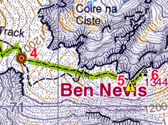
Mountain Guide Maps Accurate navigation on the
mountains is crucial to safety and success. The "TPC"
mountain guide-maps concentrate on the most relevant information for those
who take-on the National Three Peaks Challenge. They use award
winning original mapping from Harvey Maps, as used by many mountain
rescue teams, and have the
main routes highlighted on the maps together with key GPS waypoints. The reverse side of the guide-maps carry 8 figure waypoint grid references
and other route finding information of
particular importance to three peaks challenge walkers, including
critical compass bearings. The guide-maps are frequently
up-dated and revised
based on our own experience and research and
incorporate feedback from customers, mountain guides, mountain
rescue personnel and other experienced hill goers. The
features page gives more details.
The table below lists the
mountain guide-maps in the "TPC" set. See
The Guides page for details of the
full range of maps available.
To buy
the Three Peaks Challenge mountain guide-map sets for £15.95
per set, or the full Challenge Team Information Pack for £37, please phone or email -
see
contact us Extra discounts are available
for multiple map sets - please ask for a quote. |